
Custom Region – The 50% Rule
Welcome to our series on helpful tips for PolicyMap. With over 15,000 indicators of data and many features, we hope our series can help users better utilize PolicyMap. For a complete training, please join a free online session here: Click Here
Did you know the custom region feature for subscribers gives users the ability to draw right on top of the map to create their own target areas. Once a custom region is drawn, users can then open a custom region in the Tables feature to see aggregated counts or list of geographies that make up the custom region; or open in Reports to get aggregated numbers.
A custom region can contain any geography and cross multiple geographic boundaries and boundary types; we decided to create a blog series and review some of the unique rules for custom regions to make sense of how data is aggregated and how custom regions display data.
 The 50% Rule – For a geography to be included in the aggregation of a report or table, at least 50% of a geography must be contained by a custom region. This is a helpful rule for creating a radius custom region or radius report. PolicyMap will only use the geographies that have at least 50% of its area contained within the radius boundary for aggregation in a report or table. The 50% Rule also helps when drawing a custom region, since users do not have to be fully accurate in the borders. As long as the drawn border does not cross to contain more than 50% of a geography, it will then not be included in the aggregation.
In the first example on the right, only the green shaded census tracts (38.02, 38.03, 37.02, 35.01, & 34.01) would be used when aggregating data. Tracts 37.01, 35.02, and 34.02 do not have at least 50% of their area contained within the radius custom region.
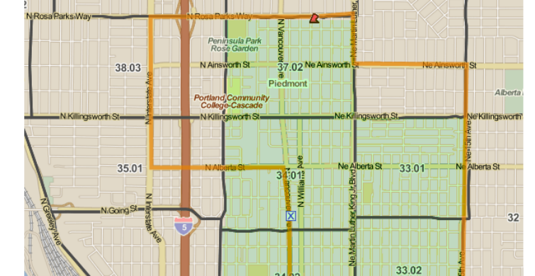
In the second example below, we have drawn a custom region following streets but these streets do not correspond to the underlying census tract boundaries. Because of the 50% Rule, our custom region will use the green highlighted census tracts (37.02, 34.01, 33.01, 34.02, & 33.02) when aggregating data, while 36.01, 38.03, and 35.01 are not included since at least 50% of their area are not contained within the custom region.

Because there is not a logical or accurate way to divide the data for a geography that is divided by the border of a custom region, we feel that the 50% Rule identifies the areas that a user most likely wanted to collect data for.
To read a full guide on all features on PolicyMap, please look at our Primer available here. If you wanted to know more about a feature or topic, send your request to info@policymap.com subject “Tutorial Topics”.