
Data Loading and Geocoding: Part I
Geocoding is the process of finding latitude and longitude coordinates for a point or address.
And I love geocoding. That makes me a little weird, but I love moving virtually across the country looking for an address, flying from Delaware to Colorado to Hawaii, getting a lay of the land, and finding where things are. Most people don’t like doing this, but by the end of this series of blog posts, you too will be geocoding like an expert.
Geocoding plays an important role in PolicyMap’s Data Loader, and it’s important that you understand how it works, and what you can do to find points when PolicyMap can’t.
So here’s the good news: the Data Loader has a good automatic geocoder. When you upload a spreadsheet of data onto PolicyMap, the geocoder takes each of the addresses in your table, and finds latitude and longitude coordinates for them. Without those coordinates, PolicyMap doesn’t know where to put the points on the map.
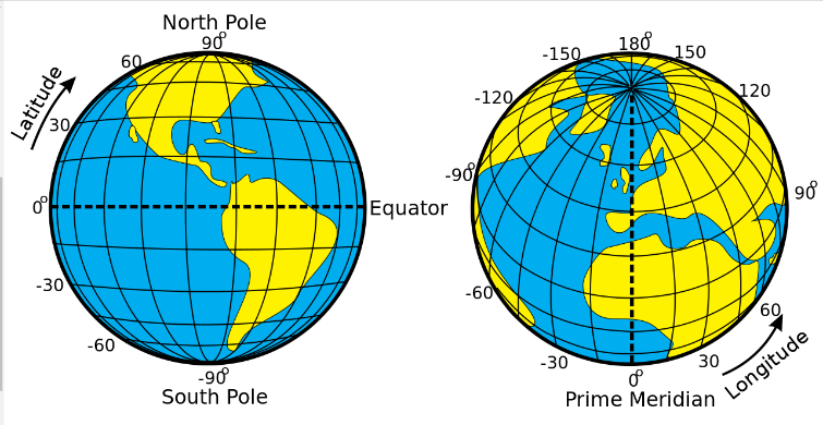
What are those latitude and longitude numbers? If you want to get technical (and why else would you be reading this blog?), if you were to stand in the center of the earth (future blog post), facing the equator and the prime meridian (a point somewhere off the coast of western Africa), the latitude number is the angle you’d have to look up to see your point on the surface of the Earth, and the longitude is the angle you’d have to turn to the right or left. Since the United States is in the Northern and Western Hemispheres, its latitude will always be a positive number of degrees and its longitude will always be negative.
Anyway, as I was saying, PolicyMap has a good automatic geocoder. If you upload a spreadsheet of 100 addresses, it can usually find 90 of them right off the bat.
As an example, I’ve uploaded a spreadsheet of hospitals in Maryland. As you can see, immediately, we have lots of green circles, meaning it was able to find those points:

In this case, it wasn’t able to find the red circle because it was a PO Box, which has no place on a map. In other cases, it can’t find addresses because they might be spelled wrong, have the wrong zip code, or be so new, it’s not in our geodatabase yet.
So what do you do about those red circles in your uploaded spreadsheet? That will be covered in the next post in the Data Loading and Geocoding series. Stay tuned.