April Data Update


PolicyMap Mapchats
 
  FEATURED POST


Analyze Neighborhood Health Trends with Expanded Community Health Report

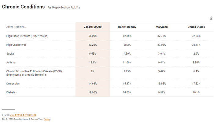
Neighborhoods separated by miles can be separated by worlds in terms of socioeconomic conditions, health resources, and outcomes. Often, addressing a city or county’s health conditions means addressing the specific conditions of certain neighborhoods.

To better assess local health conditions, the PolicyMap Community Health Reports can now be created for census tracts, in addition to counties. Census tracts are about the size of neighborhoods in cities, and towns in more rural areas. Data from a wide range of sources is available at this local geography, making it easier to understand and address local health issues.

Read More


Maximizing Health Outcomes with Opportunity Zones

Hospitals can play a leading role in efforts to attract, organize, and even make Qualified Opportunity Fund investments in the communities that they serve.

Read More


In case you missed it
 

Opioid overdose poisoning data from the CDC is updated to 2017.

Disaster Declarations from FEMA have been updated to March 2019, including the recent flooding in Nebraska and Iowa, the Ironworks fire in New Mexico, and the tornado in Alabama.

Multifamily and public housing locations from HUD are updated to 2018.

Birth data from the CDC is updated to 2017. This includes births by birth-weight, young mothers, and prenatal care. This update includes improved national coverage with fewer data suppressions.

Supplemental Security Income (SSI) data from the Social Security Administration, with data on low-income individuals who are blind, aged, or disabled, are updated to 2017.

Residential and business vacancy data from Valassis Lists is updated to 2019 Q1. More info about this subscriber dataset is available here.