
Introducing our Salesforce App
PolicyMap for Salesforce brings powerful location intelligence directly into your Salesforce environment. The app enriches your Accounts, Opportunities, and Leads with demographic, housing, and health data—providing valuable context about the communities where your clients and prospects are located. For teams new to PolicyMap, this means seeing neighborhood-level insights alongside your Salesforce records for the first time. And for existing PolicyMap users, it means seamless access to the same trusted data without switching between platforms.
What Is PolicyMap for Salesforce?
PolicyMap for Salesforce is an app that integrates reliable neighborhood-level demographic, housing, and health data directly into Salesforce, giving users location-based insights within their existing workflow.
SEE THE APP IN ACTION. WATCH THE DEMO BELOW.
Built for Organizations Like Yours
Nonprofit

Community Development Lenders

Banks

Government

Healthcare Organizations
Get In Touch
Fill in the form to contact our team for more information, personalized demos, data questions, and pricing. We’ll be in touch shortly.
Why Integrate PolicyMap Data In Salesforce
Enhance Salesforce Records
Access curated data packages for housing and housing finance, healthcare and social determinants of health, or demographics—refreshed regularly.
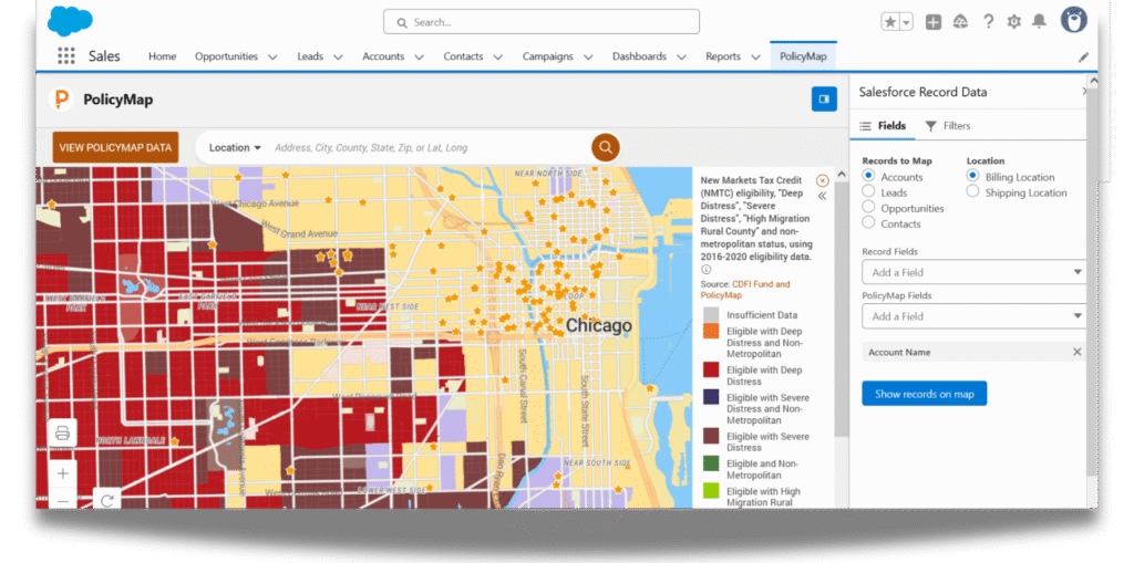
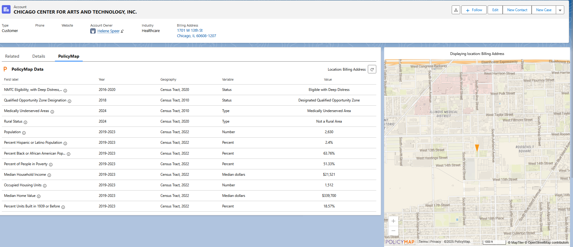
For example, housing organizations can instantly determine if accounts or leads qualify for CRA, NMTC, CDFI, Opportunity Zones, or other federal programs.
Leverage Mapping & Visualization
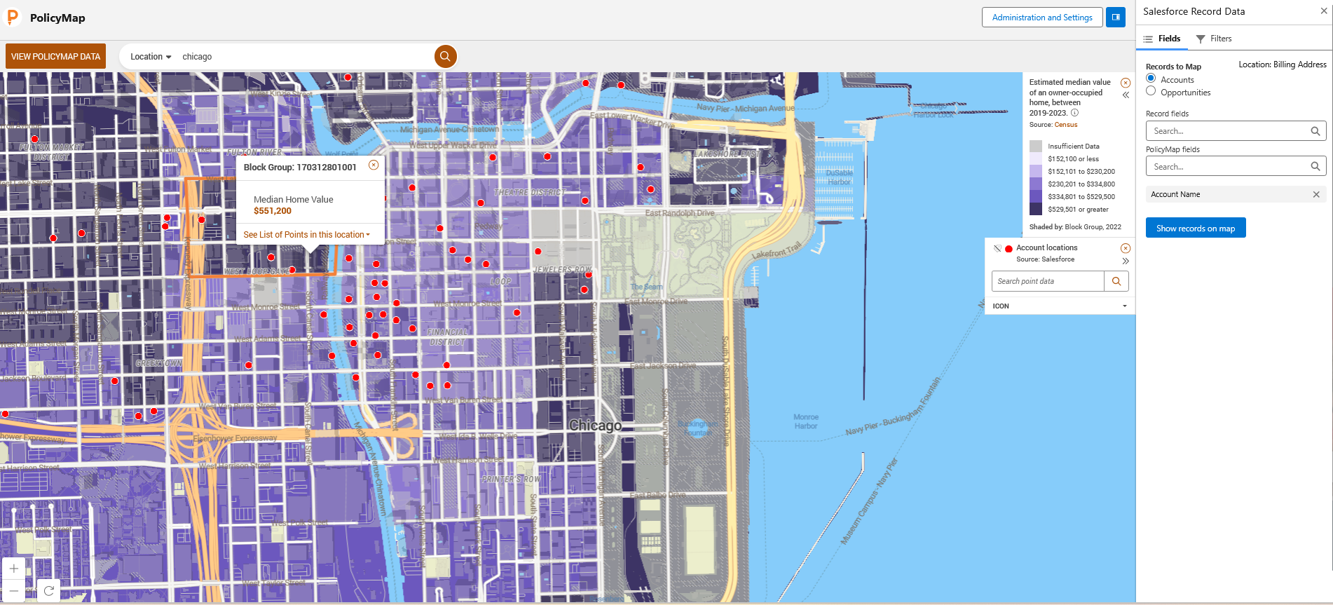
Identify gaps and consider where additional investments or activities are needed by visualizing current accounts, opportunities, or leads on a national map right within Salesforce.
For example, community and economic development organizations can streamline site selection and evaluation processes by embedding neighborhood-level data directly into their workflow.
Generate Insight-Rich Reports
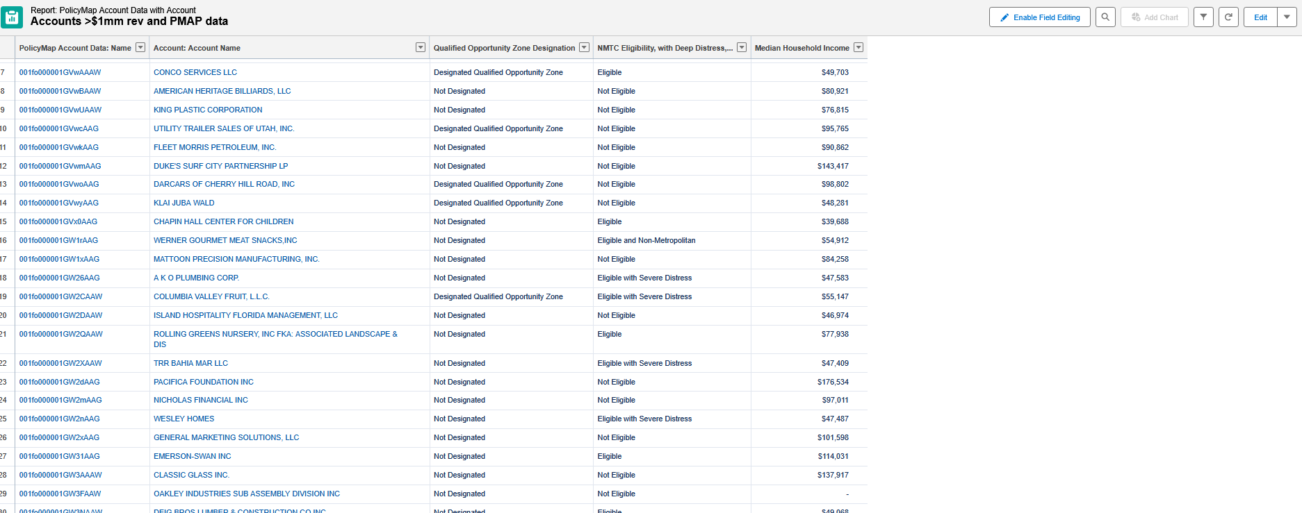
Generate and download reports of accounts, opportunities, or leads that meet certain market criteria without leaving Salesforce.
For example, nonprofits and foundations can easily identify locations that meet grant criteria.
Data Packages
Choose from datasets tailored to housing, health, and demographics.
Contact us for custom data needs.

Demographics & Neighborhood Characteristics
Explore information about the communities where you work. Includes: Age, Race, Ethnicity, Sex, Language, Foreign Born, Veterans, Household Type, Education, Housing, Financial Stability, Quality of Life, and more.

Housing
Check eligibility for federal programs, including NMTC, CDFI Fund, CRA, QCTs, and Opportunity Zones. Understand housing stock characteristics, market conditions, cost and affordability, mortgage activity, community risk, and more.
Health
Our population health data includes life expectancy and mortality, health/healthcare landscape, infrastructure/built environment, community/social context, food and nutrition, education, healthy assets/opportunities, financial stability, and environmental hazards. Where possible, our data is disaggregated by race, ethnicity, age, etc.
FAQ
Have questions? Click any question to reveal the answer. Click it again to collapse.
Can I use PolicyMap for Salesforce with custom objects and addresses?
The current version works with three native Salesforce objects — Accounts, Contacts, and Leads (using their native address fields). It also works with Opportunities, other standard objects, and custom objects that reference these three. Our v2 release will support custom address fields.
Fill in the form below to join our list and to stay on top of that release.
Are the data packages customizable?
Yes. Customers can add to existing packages or have us create a unique package for a one-time fee. Contact sales@policymap.com to learn more.
Where can I find information on how to set up the PolicyMap App on our Salesforce?
Complete setup instructions are available, click here.
I need to remove PolicyMap data from our instance of Salesforce. How do I do that?
If you’ve added PolicyMap data to your Salesforce, but now need to remove some of the indicators, just follow the steps here.
How can I connect PolicyMap data to Opportunities in Salesforce Reports?
If your Opportunities use address fields from your Accounts, Leads or Contacts, you can create Opportunity Reports using the following steps.
How can I tell which of my addresses did not get geocoded by PolicyMap?
Go to the PolicyMap folder in your Salesforce reports and click on the report named “PolicyMap Account Geocode Failed”. This report lists all of the records whose addresses PolicyMap was not able to geocode. If the address field is blank, it means the geocode failed because an address was not entered into the Salesforce record. If an address shows, it means the geocode failed because PolicyMap was not able to find the address. You will need to edit the address and rerun the connection.
Can I use the latitude and longitude of a record location instead of an address for the purpose of geocoding?
Salesforce does not have a native latitude/longitude field so we can only use an address. In future versions of the App, we will build the ability to use lat/longs.
What information will I need to provide PolicyMap in order to begin setup?
You will need to provide PolicyMap with your Salesforce OrgID, the number of seats, and the name of the data package you are purchasing.
How much does the PolicyMap App cost?
The PolicyMap App is priced by the seat and begins at an annual price of $700/seat, with a minimum purchase of 5 seats. Pricing per seat goes down as the number of seats goes up, and enterprise pricing is available. Contact sales@policymap.com for a quote, or request pricing here.
Request More Information
Fill in the form to contact our team for more information, personalized demos, data questions, and pricing. We’ll be in touch shortly.