
HUD Multifamily and Public Housing Properties Update!
Among the recent updates here at PolicyMap include several from the US Department of Housing and Urban Development (HUD): public housing and multifamily housing. Located within Federal Housing under the Add Sites tab on the left side of the Maps page, the points for these datasets contain information culled from several HUD sources, including A Picture of Subsidized Households, the Multifamily Assistance and Contracts Database, and the Real Estate Assessment Center (REAC).
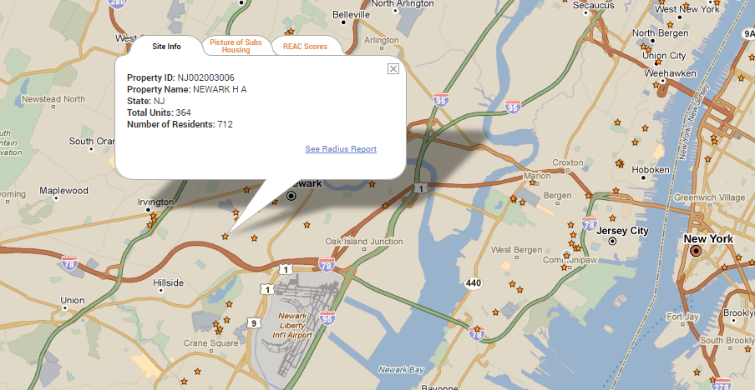
As with most of our point datasets on PolicyMap, these datasets show not only the location of public housing and multifamily properties, but also contain filters that allow users to take a closer look at certain elements of interest. For example, one area often subject to discussion is the rate of occupancy for public housing properties. As pointed out in a recent NY Times article, while overcrowding is certainly a concern, due to a number of challenges that arise in trying to match residents with the appropriate-sized apartment, a substantial number of public housing properties are actually under-occupied as well. Using the Color Code All option within this dataset’s “% Occupancy” filter, users can get a sense of where under-occupancy appears a concern.
In the map below, the red stars represent public housing properties with less than 75% occupancy. At first glance, it appears that Newark and Elizabeth, NJ, appear to have more under-occupied public housing properties than their neighbor, Jersey City, to the northeast.
Critical to obtaining a picture of public and multifamily housing is not just availability and occupancy, but also the condition of properties. According to HUD’s most recent Resident Newsletter, the agency loses 10,000-15,000 units annually due to repairs that it cannot afford to fix. Obviously, properties in disrepair have very negative implications for the quality of life of residents and surrounding communities as well. In light of these concerns, the agency’s Real Estate Assessment Center (REAC) regularly conducts physical inspections of its properties and provides each with a REAC score, scaled from 1 to 100, which determines how often the agency must return to inspect a particular property. Fortunately for PolicyMap users interested in housing, REAC scores are also a filter option on these datasets.
The map below shows the physical inspection scores of HUD multifamily properties in Cleveland, with the red diamonds represented those in the worst condition (and therefore subject to most frequent visits by the agency).
The 2011 REAC scores included in this update include property inspections that occurred between 2001 and 2009. For further explanation about how deficiencies are defined and tabulated and how REAC scores are determined, see this Federal Registrar notice from HUD or this REAC Overview document from Save Our Homes. Other filters available for these two HUD datasets include total number of units, average household income, average household rental contribution, % disabled residents, and % senior-headed households.