
Integrations
Easily integrate place-based data into your own website or application.
White Label Mapping Platform
Our white label product allows subscribers to integrate all of PolicyMap into their own business systems. The product is a full version of PolicyMap branded at your organization. White label platforms are tailored to meet your unique work requirements: custom navigation menus, unique datasets, and other branded elements.
- Access tens of thousands of indicators from hundreds of authoritative sources
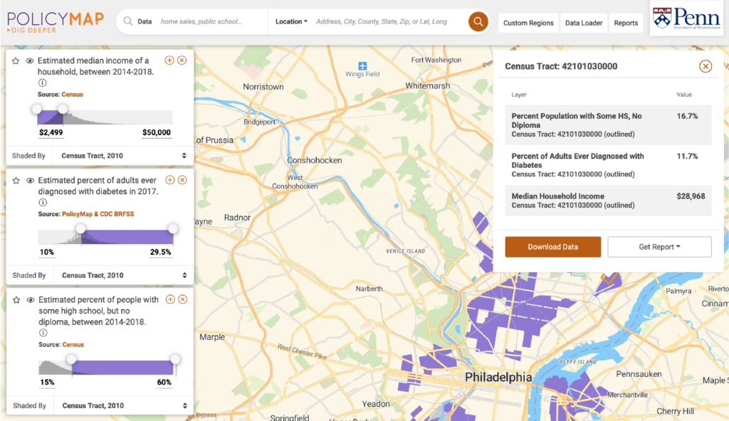
- Create compelling maps of up to five layers with our exclusive data
- Export trend charts with key benchmarks
- Download data for use in your own visualization tools
- Generate on-the-fly reports
- Upload your own data to view it with ours
Data Licensing
Focus fully on what truly matters to your business – analyzing, not collecting and updating, data. License tens of thousands of indicators from hundreds of sources through a single vendor – PolicyMap.
If your website or BI tool needs data on demographics, incomes, education, health, and more, you can license it all from PolicyMap. We offer quick and easy ways to integrate our data with your existing tool through our Data API or flat files.
Stop Collecting. Start Analyzing.
All geographic data from the extensive PolicyMap catalog can be added seamlessly to any existing 3rd party mapping or data visualization application. Contact us for a complete list of our data organized by topic and sortable by year, geography and latest update date.

Unlock the web’s largest place-based data library.
Data available through PolicyMap is authoritative and continuously updated. Data comes from trusted sources, proprietary vendors and our own expert data team.

Access data via our data API or license flat files.
Choose whether you want our data to feed directly onto your maps or tables. Or request flat files to integrate data into your own analytics.

Use a single vendor for data from hundreds of different sources.
License any of the tens of thousands of indicators available in our geodatabase through a single contract.
Let’s Talk.
Fill in the form below to receive more information about our White Label Platform and Data Licensing.
All The Data You Need. All In One Place.
Access all of the information you need about a place through a single platform or vendor. Our data comes from trusted sources, proprietary vendors and our own expert data team.

Demographics
Population, race and ethnicity, age, sex, languages, foreign born, migration and immigration, households, families, homelessness, elections, religion

Incomes & Spending
Incomes, poverty, tax returns, federal benefits, bankruptcies, housing burdens, consumer spending, medical spending

Housing
Home sales, rents, building permits, residential & commercial vacancy, subsidized households, public housing, LIHTC

Lending
Mortgage originations, government insured loans, refinance loans, mortgages by race, ethnicity and income, bank branches, credit unions, Historic Lending Boundaries

Quality of Life
Crime, broadband access, time to work, heating fuel types, food access, farmers markets, environmental hazards, libraries, museums, parks, disaster risk

Economy
Jobs, unemployment, wages, small business, employment, workforce characteristics, oil and gas production

Education
School enrollment, educational attainment, graduation rates, school performance, cost of college, student loan debt, school locations, college locations, head start locations

Health
Infectious diseases, opioid use, chronic conditions, access to health care, health insurance, health risk factors, federal health programs, health facility locations, food access

Federal Guidelines
NMTC eligibility & investments, Opportunity Zones, persistent poverty, CDBG eligibility, housing opportunity index, CRA eligible areas, SBA HUB Zones, Promise Zones
Data available through PolicyMap is authoritative and continuously updated.