
A Deeper Look at Gerrymandering
Most redistricting coverage asks which party gains; we’re asking what happens to the data. For the health systems, foundations, community development organizations, and federal grantees that work by congressional district, mid-decade redraws can make district numbers incomparable to their own history. This is the first article in a three-part series on redistricting: what gerrymandering is and how it works. Part two covers what can be done about it; part three tracks what changed in 2025 and 2026.
We first published this explainer in 2017. Nearly everything in it about how gerrymandering works is still accurate; nearly everything about the law is not. Supreme Court decisions since then have removed most of the constraints it described, and we have rewritten it from the ground up.
Start with a district that no longer exists
In 2024, Missouri’s 5th Congressional District was anchored on Kansas City. In September 2025, in a special legislative session, Missouri redrew the map and split the city apart. No one moved. The lines did.
Missouri ran its August 4, 2026 primary on the new lines. On September 3 the Missouri Supreme Court unanimously blocked them from the November election, holding the referendum petition valid and putting the map to a statewide vote: the first time a congressional plan has gone before Missouri voters since 1922. On September 8 Justice Brett Kavanaugh, as circuit justice for the Eighth Circuit, declined to disturb that ruling — acting alone, without referral to the full Court and without reasons — and hours later a federal trial court blocked the 2022 map instead. On September 10 the full Court stayed that order, unsigned and with no noted dissents, four changes of status in eight days.
The map itself goes to voters as Proposition A on November 3. A yes approves the 2025 boundaries; a no keeps the 2022 ones.Which lines would govern November was fought over until the last week of September. On September 21, 2026, a divided Eighth Circuit panel held that switching maps between the August primary and the November general election violates Article I, Section 2 of the Constitution, and ordered the 2025 map back into use. It then kept that order from taking effect until September 28 so the Supreme Court could review it. The referendum’s sponsors applied to the Court on September 22, its third look at the case in a month, and on September 25 the Court blocked the Eighth Circuit’s order, unsigned and with no public dissents, because the election “has already started.” November runs on the 2022 lines: ballots for military and overseas voters went out on them on September 18, and absentee voting opened on them September 22.
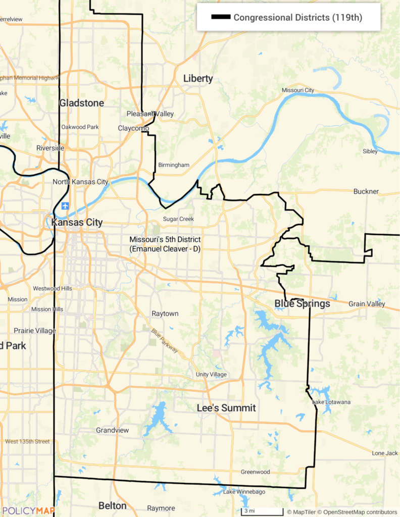
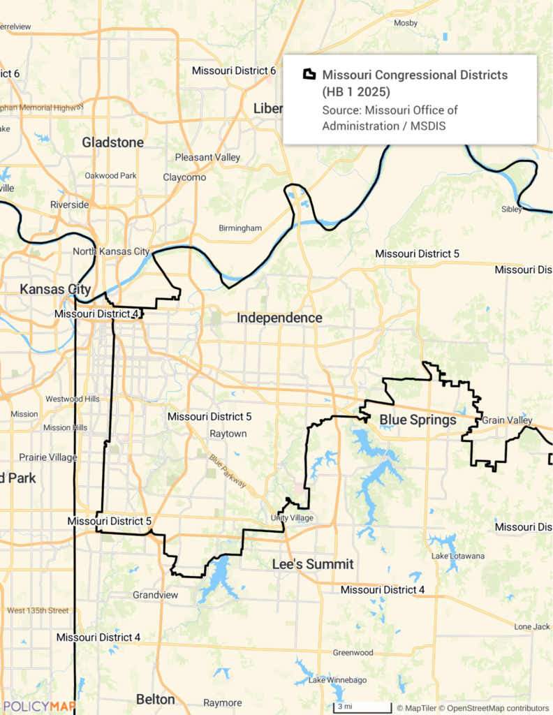
That is gerrymandering in its most literal sense: drawing boundaries to produce a political result rather than to describe a community. What is unusual about 2025 and 2026 is not that it happened, but that it happened mid-decade, across ten states at once, and as a national strategy.
As of September 25, 2026: ten states have moved to redraw their congressional maps since mid-2025, and eight of those maps are in effect for November. Missouri’s is blocked pending the referendum. Virginia’s never took effect, because its supreme court struck down the constitutional amendment the map depended on. Eight more states had mid-decade redistricting on the table and did not carry it out, in both parties’ statehouses, and in two more the only challenge has run through the courts. We track all of it, state by state, on our state-by-state redistricting tracker.
Alabama belongs in this story but not in that list, because it adopted nothing: the U.S. Supreme Court stayed an injunction on June 2, 2026, restoring a map the legislature passed in 2023 and a federal court had repeatedly blocked. Alabama will vote in November under different lines than it used in 2024, and no legislature, commission, court-drawn plan or ballot measure changed them.
Where the word comes from
The term dates to 1812, when Massachusetts Governor Elbridge Gerry signed off on a state senate map with a district so contorted that a cartoon reprinted in a Boston newspaper drew it as a salamander: a Gerry-mander. Congressional maps are redrawn after each decennial census, and in most states the legislature draws them, so the party in power at the start of a decade generally controls the lines for the rest of it.
What the Constitution actually requires
Equal population is a federal requirement. In Wesberry v. Sanders (1964) the Supreme Court held that congressional districts within a state must contain substantially equal populations: one person, one vote. That constraint is still binding.
Contiguity and compactness are not. They are creatures of state law, and they vary: many states require contiguity, fewer require compactness, some require respect for county and municipal lines, some require none of it. A district can be as strangely shaped as a state’s own law allows, which is most of the reason a map struck down under Pennsylvania’s constitution would survive in Texas.
The two basic techniques
Almost all gerrymandering reduces to two moves, and they are opposites.
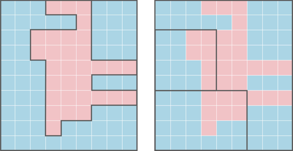
Packing concentrates a group’s voters into as few districts as possible. Those districts are won overwhelmingly, every vote beyond what was needed to win is wasted, and the group’s influence everywhere else drops accordingly.
Cracking does the reverse: it splits a group across many districts so that it constitutes a majority in none of them. Missouri’s 2025 split of Kansas City is a textbook example.
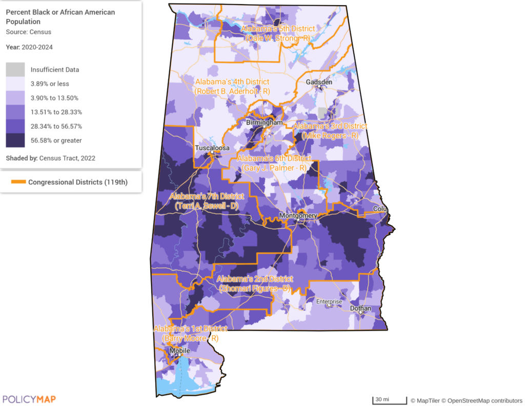
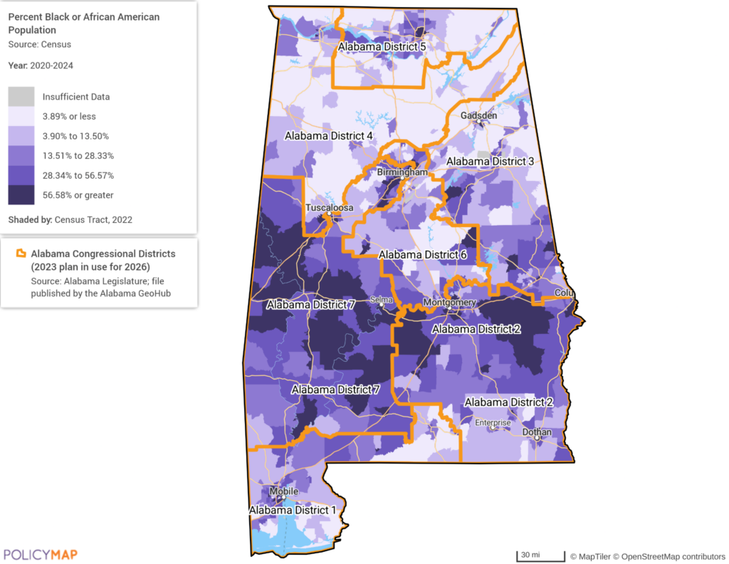
Credit: Map: PolicyMap. District boundaries: Alabama Legislature, Livingston Congressional Plan 3-2023 (SB 5, 2023); boundary file: Alabama GeoHub. Population: U.S. Census Bureau [PolicyMap layer vintage — fill from the legend].
Concentration by itself is not evidence of gerrymandering. Voters sort themselves geographically (cities lean one way, rural areas another) and a district drawn around a city will look packed without anyone intending it. The question is whether the concentration reflects how people live or was manufactured to produce a result.
The part that used to be required
For most of the last sixty years, some packing was not merely permitted but legally mandated. Section 2 of the Voting Rights Act of 1965 prohibits maps that dilute the voting strength of racial and language minorities, and under the test the Supreme Court set out in Thornburg v. Gingles (1986) a state could be required to draw a majority-minority district (one where a group that is a minority statewide makes up a majority of that district’s voters) so the community could elect a candidate of its choice. On Ballotpedia’s count from 2024 Census estimates, 148 of the 435 House districts are majority-minority in the broad sense — minority residents together make up more than half the district’s total population. The districts Section 2 actually required are a smaller subset of those: the ones where a single minority group holds that majority, which is the test that line of cases set.
That machinery is no longer working. In Louisiana v. Callais, decided 6–3 in April 2026, the Court struck down a Louisiana map that created a second majority-Black district, holding it an unconstitutional racial gerrymander. The state had drawn that map specifically to comply with a Section 2 ruling. Anyone bringing a Section 2 vote-dilution claim must now clear a substantially higher bar: in Justice Kagan’s dissent, a challenger has to show not just dilution but a race-based motive, which she described as nearly impossible to prove. Majority-minority districts are now best described in the past tense — districts the Voting Rights Act used to require, and that will be very hard to create from here.
Race, districts, and the line the courts drew
Shaw v. Reno (1993) set the constitutional limit on that machinery. White voters challenged a North Carolina map that created a second majority-Black district (District 12, so narrow it followed an interstate highway for much of its length) and the Supreme Court held that a district drawn so irregularly that it can only be explained by race may state a claim under the Equal Protection Clause. Race-predominant districting is constitutionally suspect even when the state’s stated purpose is complying with the Voting Rights Act.
That tension, a statute sometimes requiring race-conscious maps, a constitutional clause limiting how far that could go, ran through the next three decades of redistricting law, and North Carolina’s maps returned to the Court repeatedly, including in Cooper v. Harris (2017), where the Court found the state had again let race predominate without adequate justification. Callais resolves the tension by largely removing one side of it.
Communities of interest
Beyond party and race, cracking damages something harder to quantify: the ability of a place to be represented as a place.
Many states require map-drawers to respect communities of interest: populations that share economic, social, cultural or geographic concerns and benefit from being represented together. A river town, a metro area’s industrial corridor, a reservation, a county with a distinctive economy. Split one across several districts, and it stops being anyone’s priority: each representative serves a fraction of it, and no one answers for the whole. It is why Missouri’s Kansas City split is not only a partisan story.
With Section 2 substantially weakened, communities-of-interest requirements under state law are now among the more important surviving constraints on map-drawing.
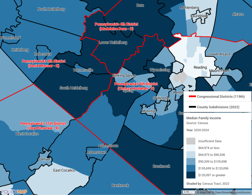
Credit: Map: PolicyMap. District boundaries: U.S. Census Bureau, 119th Congress districts (Pennsylvania’s 2022 plan). Income and poverty: U.S. Census Bureau, American Community Survey 2020–2024 five-year estimates, tables B19013 and S1701.
Two more techniques worth knowing
Sweetheart gerrymandering, or a bipartisan handshake, is what happens when both parties agree to draw safe seats for their own incumbents. No party gains overall, incumbents of both parties become nearly unbeatable, and it is bad for voters for exactly the reason it is good for officeholders.
Prison gerrymandering arises from a Census Bureau practice: incarcerated people are counted as residents of the place where the prison sits, not where they lived before incarceration and usually not where they will return. In most states they cannot vote. The effect is to shift population, and therefore representation, from the communities people came from to the communities where prisons are located. This is the one part of the picture that has meaningfully improved since 2017: more than a dozen states have passed legislation ending the practice, most by counting incarcerated people at their home addresses, and on the Prison Policy Initiative’s count, nearly half of U.S. residents now live in a state that has formally rejected it. The federal Census practice itself has not changed.
What happens next
The 2017 version ended by promising a follow-up on how to measure gerrymandering and what to do about it. That follow-up ran a week later, seven weeks after the Court had already agreed to hear the Wisconsin case, and it was confident about how that case would come out: “If the Supreme Court decides to deny Wisconsin’s appeal, the efficiency gap is likely to be used in many other states to force redistricting.” We expected a ruling that would hand federal courts a workable standard for policing partisan maps. Instead, the Court decided the Wisconsin case on standing without reaching the efficiency gap, and then, in Rucho v. Common Cause (2019), held that partisan gerrymandering claims cannot be heard in federal court at all. We did not get the decision we predicted, and then we lost the forum.
We have rewritten that piece too. It now describes where the fight went instead: state courts, state constitutions, state voting rights acts, and the design of the bodies that draw the lines. Read part two on solutions to gerrymandering.
Pennsylvania is the clearest example of that route working, and the reason none of this is settled history. The 2011 map was struck down under the state’s own constitution in 2018, and the map Pennsylvania uses today was chosen by the state supreme court after the legislature and the governor deadlocked. Nothing in Pennsylvania law forbids redrawing a congressional map mid-decade; what has kept it off the table is arithmetic. On the National Conference of State Legislatures’ count in January 2026, Pennsylvania was one of only three legislatures in the country split between the parties — a Democratic House and a Republican Senate, with Michigan and Minnesota the others. Single-party control after 2026 would remove that barrier, and the map we are using here as evidence that the state-court route works would be back in play.
One further question we intend to take up separately: a district is a unit of measurement as much as a political one, and when the container changes mid-decade, district-level numbers stop being comparable to their own history, not because anything on the ground changed, but because the thing doing the counting moved.
Request More Information
When district lines move, the data inside them moves too. If your organization reports, plans or briefs by congressional district and needs to see how the boundaries line up with the communities you serve, fill in the form below. Our sales team will be in touch shortly.