
County Subdivisions: The Secret Geography
Census tracts get all the glory. As do block groups, ZIP codes, counties, and states. But what if I told you, there’s an amazing geography you’ve probably never used?
Enter county subdivisions. They are smaller than counties (duh), and larger than most census tracts and ZIP codes. They’re better known as townships, towns, cities, districts, boroughs, barrios, villages, plantations (not those plantations—they’re in Maine), municipalities, subdistricts, reservations, counties (which are not the same as counties), grants, purchases, locations, gores (!?), and islands. These are all minor civil divisions (MCDs), meaning they’re legal – not just statistical – entities.
Some states don’t have minor civil divisions, so the Census just draws up their own subdivisions, calling them Census county divisions (CCDs) and Census subareas. Some states with minor civil divisions have areas with no legally established MCD; the Census defines those as unorganized territories (UTs). These are all purely statistical entities, with no local legal recognition.
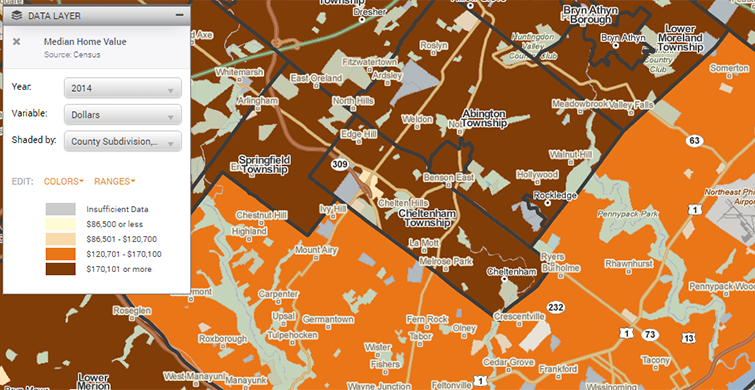
 I grew up in Cheltenham Township, Pennsylvania. It has its own police department and school district, and is governed by a Board of Commissioners. All the street signs are blue and gold (go Panthers!). If I wanted statistical information about it, looking at Montgomery County as a whole wouldn’t be too useful, since it’s much bigger and geographically diverse. I could look at the smaller census tracts that are inside of Cheltenham, but that would only tell you about its different parts. For a look at the township, the whole township, and nothing but the township, county subdivisions would be the way to go.
Everything else you could possibly want to know about county subdivisions is here: https://www.census.gov/geo/reference/gtc/gtc_cousub.html.
So why are these geographies so “secret”?
 You don’t see county subdivisions by default on PolicyMap. To see data shown at the county subdivision level, you have to go to the “Shade by” menu in the legend, and click on it. Not all data is available at this level, but Census and American Community Survey data is. Some data, like HUD’s Fair Market Rent data, is available primarily at county subdivisions.
- If you want to search for a county subdivision, you can just type it into the Location search bar. Though it won’t show up in the suggestions menu, if you type the name and state, and press enter, it’ll find it. (They don’t appear in the suggestions menu simply because there are so many geography types, we have to draw the line somewhere to keep the menu from being overwhelming.)
- Why don’t they show up by default when you zoom in on PolicyMap? Most people want to see the smallest, most granular geography available, and when you zoom in close enough to see county subdivisions, you can generally see census tracts as well (and census tracts get all the glory).
- We’ve recently made a change to how county subdivisions appear on PolicyMap when you load map boundaries (from that little menu under the map). On the map, the labels used to just give the name, without the legal suffix (so, just “Cheltenham”). Eagle-eyed PolicyMap users will notice that the legal suffix is now displayed as well (“Cheltenham Township”)


County subdivisions (or “cousubs,” as we like to call them) are a pretty great geography type that’s easy to overlook. Next time you want data for a township (or the like), check them out.