
Custom Region – Assembled Custom Region Rules
Welcome to our series on helpful tips for PolicyMap. With over 15,000 indicators of data and many features, we hope our series can help users better utilize PolicyMap. For a complete training, please join a free online session here: Click Here
Did you know the custom region feature for subscribers gives users the ability to draw right on top of the map to create their own target areas. Once a custom region is drawn, users can then open a custom region in the Tables feature to see aggregated counts or list of geographies that make up the custom region; or open in Reports to get aggregated numbers.
A custom region can contain any geography and cross multiple geographic boundaries and boundary types; we decided to create a blog serie and review some of the unique rules for custom regions to make sense of how data is aggregated and how custom regions display data.

Geography by Assembled Custom Region – The geography which was used to assemble a custom region will be the default geography used to aggregate data. For example, if you assemble a custom region by blockgroups, then the default geography used in reports or tables are blockgroups. This is helpful if you want to download data using the See Values features in Tables. Simply assemble a custom region on the Maps page by the geography you want to download data for, and the See Values will default to that geography.
Donuts in Assembled Custom Regions – When assembling a custom region by selecting the geographies around an area, PolicyMap will automatically fill in the middle of the “donut” when saved, but will only use the geographies selected to aggregate. PolicyMap will not include the geographies in the middle of the “donut”, even though the shaded area is filled in. In the example on the right, the highlighted area will only be used in aggregation but the custom region will “fill in” the area inside the donut when saved.
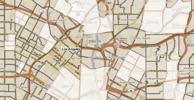
Non-contiguous Assembled Custom Regions – Assembling a custom region has a unique feature, it allows a custom region to contain geographies that do not have contiguous borders or borders which do not touch each other. In the example below, a user wanted to get aggregated data for specific census tracts throughout downtown Los Angeles, CA. The user is able to individually select each census tract to create a custom region. The custom region can then be opened in Tables to download data for the selected census tracts or in Reports to get aggregated data for the selected census tracts also.
 Example of assembling a non-contiguous custom region
While there is not a limit on how many geographies can be selected when assembling a custom region, the total number will increase the amount of time it takes PolicyMap to process and save the custom region.
If there are any unanswered questions about the custom regions feature or you would like to learn more about PolicyMap, join us in our free weekly training or contact us at pmap@policymap.com.
To read a full guide on all features on PolicyMap, please look at our Primer available here. If you wanted to know more about a feature or topic, send your request to info@policymap.com subject “Tutorial Topics”.