
Did you know… (Aerial Maps)
Welcome to our series on helpful tips for PolicyMap. With over 10,000 data indicators and many online features, we hope our series can help users better utilize PolicyMap. For a complete training, please join a free online session here: Click Here
Did you know you can now use PolicyMap to see what a place actually looks like. We’ve added GoogleMap’s aerial images, which can now appear side by side next to PolicyMap’s shaded indicator map. Here at PolicyMap, we’re very excited about this new feature, so here’s a little tour of how it works.
Let’s say you’ve found an area of interest, such as census block group data in North End Boston with varying levels of median income. To enable aerial images, click on “Aerial” in the middle of the purple bar below the map.
This will bring up a Google aerial map side by side with a shaded PolicyMap. The two maps will be placed identically, with the zoom level and location matched.

![]() You can remove the street labels from the aerial map by deselecting the “Labels” toggle in the upper right corner. This may make it easier to see the areas you’re investigating.
You can remove the street labels from the aerial map by deselecting the “Labels” toggle in the upper right corner. This may make it easier to see the areas you’re investigating.
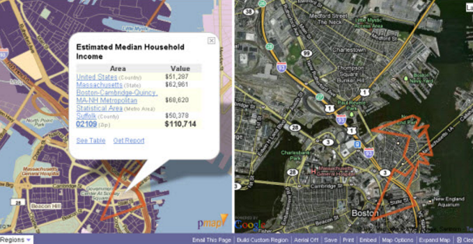
When a location is selected in PolicyMap, the same outline will appear on the aerial image.

Now, you might want to zoom in to get a better look. As usual, you can zoom in on PolicyMap, and the aerial image will zoom correspondingly. Once you’re at the closest zoom level, new zoom controls will appear on top left of the aerial image. With these, you can zoom even closer on the aerial map, though PolicyMap will remain the same. If you pan around on either map, the other map will also pan around so that the two have the same center.

When you have aerial images enabled, most of PolicyMap will work the same as it always does. You can choose new data layers and set a new location, just like usual. However, saving, printing, and embedding will not include the aerial image due to license restrictions from Google.
Enjoy the new feature, and keep checking the blog for more articles about interesting ways to use these aerial images!
Read our Quick Start Guide to learn the basics of PolicyMap and jump right into using the power of data. If you wanted to know more about a feature or topic, send your request to info@policymap.com subject “Did you Know…”
Sincerely,
The PolicyMap Team
![]()