
Mapping the Interplay of Flood Risks, Population Density, and Property Values in Southern Florida
Data
FEMA National Flood Hazard Layer
Source
Federal Emergency Management Agency (FEMA)
Find on PolicyMap
- Housing
- Flood Risk
PolicyMap’s Premium Subscribers can now access the updated 2023 FEMA Flood Maps which provide an in-depth risk analysis of flood hazard zones. Current subscribers can find more information about the different flood risk classifications in our Data Dictionary.
Using FEMA Flood Maps
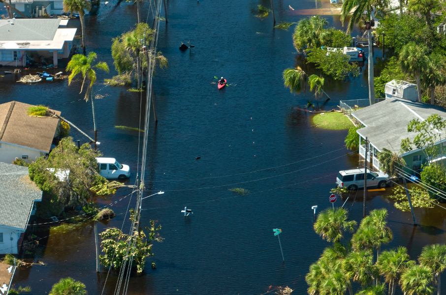
Let’s take a closer look at flood-prone communities in Southern Florida. The impact of floods is acutely felt in Florida’s vulnerable zones, as well as many coastal regions throughout the United States. If climate change continues, causing oceans and the atmosphere to warm, the U.S. Environmental Protection Agency (EPA) predicts rising sea levels will submerge wetlands and dry land, erode beaches, and exacerbate coastal flooding.
The 2023 Flood Maps from the Federal Emergency Management Agency (FEMA) serve as a poignant reminder of the escalating threats faced by numerous regions across the state. Particularly alarming is the surge in flood susceptibility along Florida’s coastal areas, a factor contributing to the disconcerting trend of insurance companies withdrawing from the state. With the updated FEMA Flood Maps, PolicyMap’s subscribers gain access to a wealth of insights that possess the power to shape strategies, policies, and proactive responses to the pressing challenges at hand.
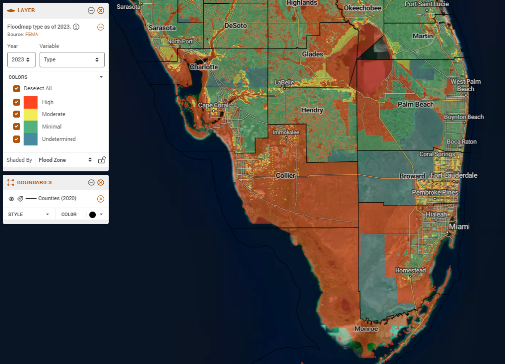
Flood Maps in Southern Florida
Our first map shows the 2023 Flood Maps in Southern Florida, showing the intricate relationship this region maintains with the ocean and the Everglades, catalyzing concerns of paramount significance. Southern Florida, renowned for tropical weather and luxury waterfront properties, is equally characterized by the perils it harbors. The magnetic pull attracting individuals from various walks of life to this sun-soaked paradise is countered by an undeniable reality: a multitude of cities within this picturesque landscape are enveloped by flood zones. This spatial juxtaposition accentuates the delicate equilibrium between the coastal charm and the imminent dangers posed by escalating water levels. This map serves as a clarion call for conscientious decision-making and strategic planning, compelling us to address the complex relationship between nature’s enticements and its capriciousness.
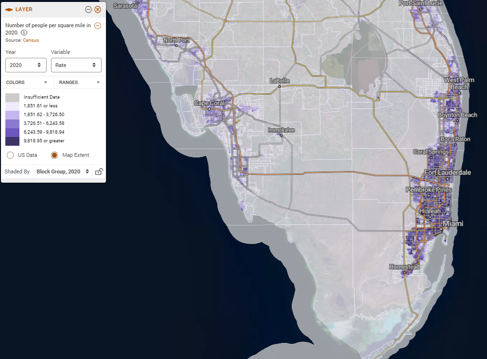
Population Density in Southern Florida
The second map illuminates the human pulse coursing through Southern Florida’s urban communities, with a spotlight on bustling metropolises like Miami, Fort Lauderdale, and West Palm Beach. Through its dynamic visualization, the map unveils the intricate tapestry of human presence, offering a snapshot of urban life and the tightly woven communities that define the region. PolicyMap’s Population Density dataset shows the extent to which South Florida’s population is heavily concentrated on its coasts, which as seen in the previous map, are the most at risk of flooding.
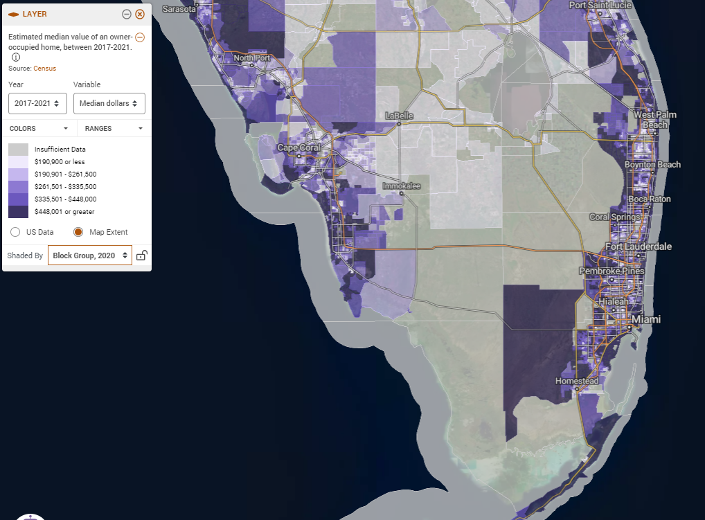
Property Value in Southern Florida
The third map directs our attention to Southern Florida’s property value dynamics, molded by a combination of factors including location, market trends, and regional economic undercurrents. Urban centers such as Miami, Fort Lauderdale, and West Palm Beach experience diverse trajectories in property valuation, often shaped by their proximity to waterfronts, amenities, and cultural landmarks. But alongside the proximity to waterfronts, comes the inherent risk of flood damage. With many homeowner’s insurance companies no longer providing coverage in Florida, affordable single-family homes and million-dollar mansions alike are at risk of being damaged or destroyed by floods, with no insurance coverage for property owners.
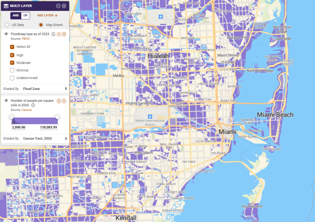
Multi-Layer Map of Flood Zones and Population Density
Our fourth map presents a compelling narrative by spotlighting extensive areas of heightened population density within flood-prone zones. This visualization unequivocally highlights the vulnerability of hundreds of thousands of dwellings, and millions of residents, to potential risks. The susceptibility of these homes is compounded by the discernible retreat of many insurance companies from Florida, mirroring the mounting trepidation surrounding the state’s vulnerability to floods stemming from hurricanes and the sweeping ramifications of climate change. As Florida grapples with these concurrent environmental challenges, the confluence of population density within flood-vulnerable regions mandates the formulation of informed strategies and comprehensive policies to confront the multifaceted risks intertwined with this intricate landscape.
Flood Resilience Plans for High-Risk Communities
As our series of maps illustrates, Southern Florida is ensnared in a complex interplay of flood risks, population density, and property values. These visual insights underscore the urgency for proactive measures, data-informed decision-making, strategic planning, and the formulation of comprehensive policies to safeguard the region against the escalating challenges posed by climate change-induced floods. In an era where knowledge is paramount, PolicyMap’s resources empower subscribers to be architects of resilience within this dynamic landscape.
To learn more about flood risks and flood insurance, take a look at FEMA’s National Flood Insurance Program.
Request More Information
Are you interested in PolicyMap’s datasets, such as the 2023 FEMA Flood Maps? Fill in the form below to receive information about subscriptions and data licensing.