
Invest In Safer Streets For Everyone Using The EPA’s National Walkability Index

Data
Smart Location Database
Source
Environmental Protection Agency (EPA)
Find on PolicyMap
- Quality of Life
- Transportation
- Walkability
- Transportation
Walking is good for our health and good for the planet. According to the CDC, walking even smaller amounts throughout the week can add up to better physical health. And the environmental impact of walking instead of driving for short trips could be huge. The EPA estimates that if Americans walked instead of drove for half of the trips under 1 mile, it would save 2 million metric tons of carbon dioxide emissions per year—the equivalent of taking 400,000 cars off the road. Knowing what areas are most likely to foster walking for transportation can help shift people out of their cars and onto the sidewalks. To help encourage walking, the EPA has created the National Walkability Index based on factors that research has shown to increase the number of trips people take by walking.
Walkable Neighborhoods
A diverse mix of land uses, such as shops, restaurants, residences, and office space, within a neighborhood can encourage walking. People are also more likely to walk in areas with denser street networks—such as a dense city center. Rich and nearby public transit options also promote walking. The EPA’s National Walkability Index captures these three contributors to walkability in a single index, where higher numbers represent more walkable areas.
The map below shows the contrast between walkability scores in the dense urban environment of downtown Los Angeles compared to the neighboring Vernon.
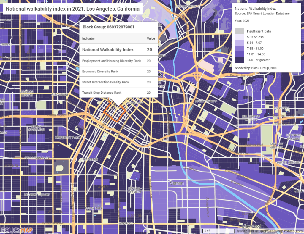
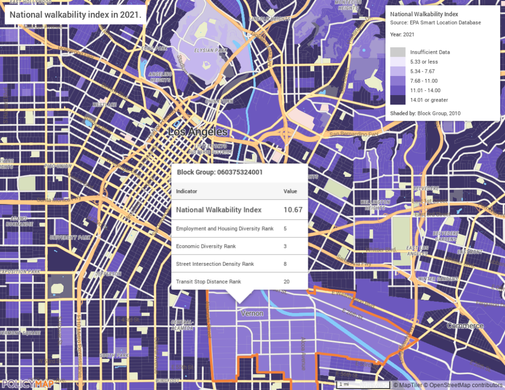
While both neighborhoods receive a top score for public transit access, Vernon’s score is lower because of its less-dense street network and less diverse mix of businesses.
Safer Streets for Everyone
Unfortunately, in some areas walking can be unsafe—in 2019, over 6,000 pedestrians died in motor vehicle crashes, and a further 76,000 were injured, according to government crash statistics.
The National Walkability Index can highlight areas where investment in safer street infrastructure, such as high-quality sidewalks, curb cuts, and lower motor vehicle speeds, might make the greatest improvement.
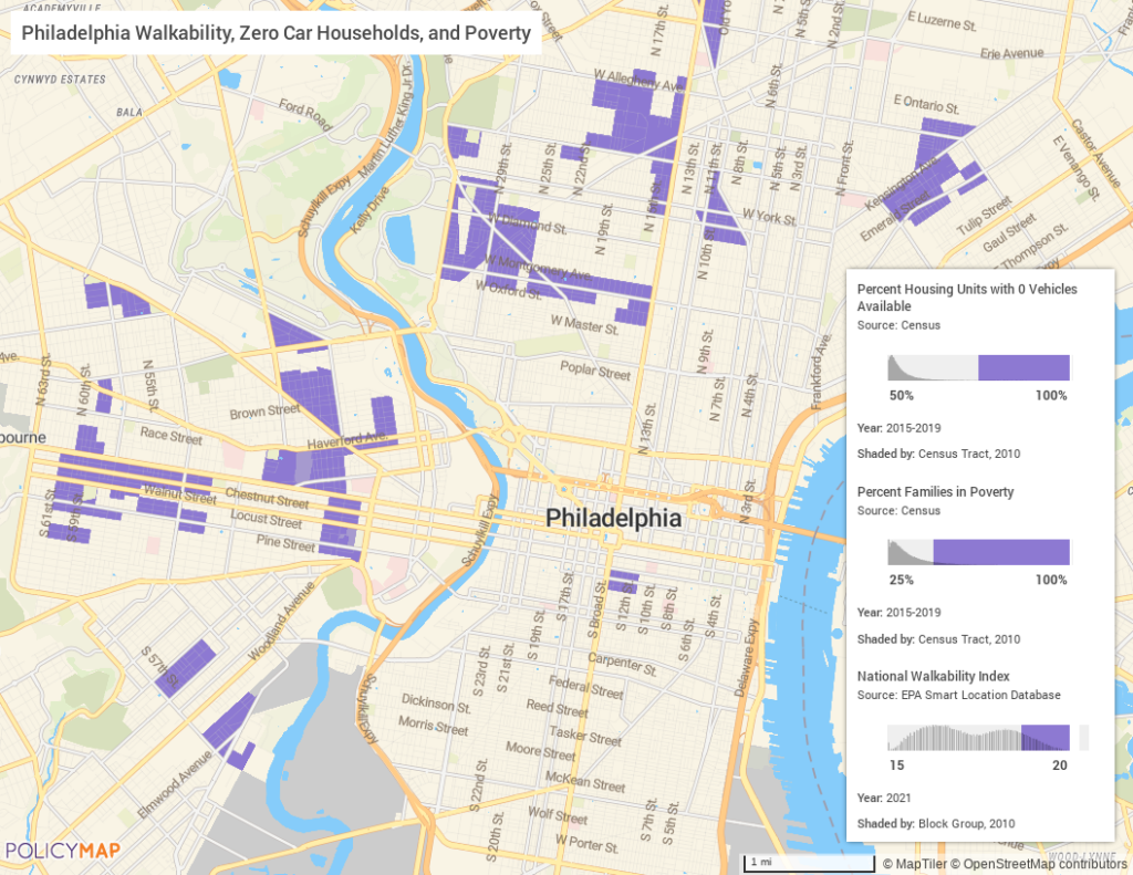
The following map shows areas in Philadelphia where more than half of households do not have a car, more than 25% of families earn below the federal poverty level, and the areas score high on the National Walkability Index. These neighborhoods might benefit significantly from investment in pedestrian facilities.
The full Smart Locations Database includes information on frequency of transit service per hour and per mile, job and worker accessibility by auto travel and transit commute, economic diversity, road network density, intersection density, and walkability. Want to learn more? Contact PolicyMap.