Search by Census Tract and Block Group
Did you know you can search for small geographies like census tracts and blockgroups. Finding census tracts and blockgroups is useful on the Maps page if you want quickly zoom into a neighborhood or on the Tables page to compare smaller geographies. To search for these small geographies, just select the Census Tract or BG (for block group) tabs from the Set Location bar.
PolicyMap has simplified how to search for tracts and blockgroups by giving users the ability to enter a FIPS (Federal Information Processing Standard) code. Enter the FIPS code in the respective tabs and the map will locate and highlight the boundary for that geography.
The suggested locations for tracts and blockgroups will appear after the 10th digit for tracts and 11th digit for blockgroups, and both will display the boundary year(s) each geography was created.

Here are some examples of suggested geographies in the Set Location bar and what they mean;
- Census tracts and other geographies labeled “2000 and 2010 boundary” means that the FIPS code did not change and the boundary did not significantly change between the 2000 and 2010 Census.

- Census tracts and other geographies labeled “2000 boundary” or “2010 boundary” means that between the 2000 and 2010 Census the FIPS code change, or the boundary significantly changed, or both.

- Census tracts and other geographies which appear twice with “2000 boundary” or “2010 boundary” separately means that between the 2000 and 2010 Census the FIPS code did not change but the boundary significantly changed.

Please note: Blockgroup suggested locations will never display a FIPS code with “2000 and 2010 boundary” and will always show the FIPS code with either “2000 boundary” or “2010 boundary“.

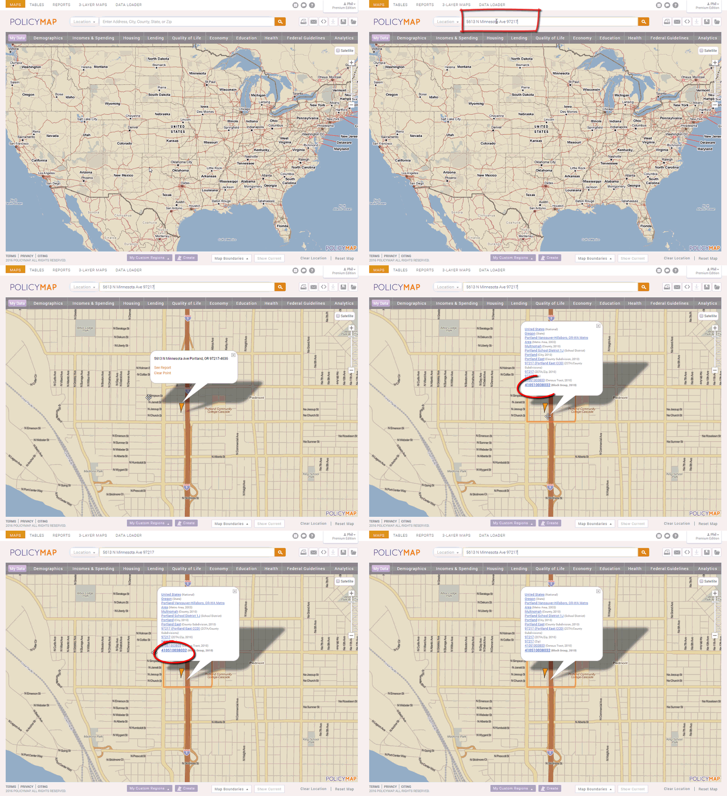
If you do not know the census tract or blockgroup ID which an address is in, here are simple instructions on how to retrieve the information using PolicyMap.
- Go to PolicyMap and clear any data layer
- Search for a general geography your area would be located (e.g. city, county, zip code, or actual address)
- Click on the location of your area and the information bubble will display a variety of geographies including; state, county, city, census tract number, and blockgroup number
- – Depending on the zoom level, the geography in bold will be the geography highlighted on the map.

Read our Quick Start Guide to learn the basics of PolicyMap and jump right into using the power of data. If you wanted to know more about a feature or topic, send your request to info@policymap.com subject “PolicyMap Tutorial”.