
The Geography of Farmland
Data
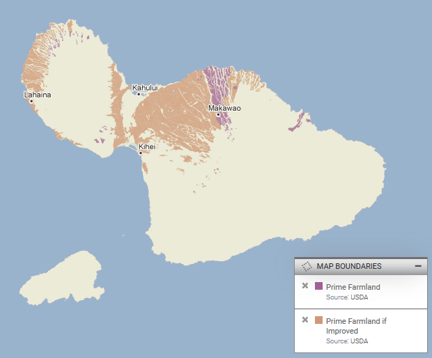
Prime Farmland
Source
United States Department of Agriculture (USDA), Soil Survey Geographic (SSURGO) Database
Find on PolicyMap
- Map Boundaries
- Prime Farmland
- Prime Farmland if Improved
You can’t grow food just anywhere. Farms require fertile soil, which is the result of thousands of years of natural processes and the right conditions. And although it’s possible to improve certain lands for agriculture, the amount of arable soil in the world is rapidly shrinking.
The SSURGO database from the USDA is a national map of soil information, including information on the suitability of certain soil types and environmental conditions for growing crops. SSURGO stands for “Soil Survey Geographic Database”, and its information is collected by the National Cooperative Soil Survey.
The farmland designations in the SSURGO database offer insight into the soil conditions across the U.S. and their suitability for growing crops. While most people likely associate farms with rolling hills of wheat or corn, I grew up on a farm in Hawaii (not far from where Kilauea is currently erupting), so I focused on the farmland in my home state.
What are prime farmland designations?
A prime farmland designation is defined as land that is made up of a combination of physical and geological characteristics suitable for producing crops. According to the National Soil Survey Handbook, these include having:
- Adequate and dependable water supply from precipitation or irrigation
- Favorable temperature and growing season
- Acceptable level of acidity or alkalinity
- Acceptable content of salt or sodium
- Few or no rocks
Prime farmland soil is also permeable and not eroded, consistently waterlogged, or consistently prone to flooding. Prime farmland definitions only take into consideration current land use, so areas that are urban, built-up, or covered by water (as defined by the National Resource Inventory, or NRI) are not included in the designation.
There is also a designation of “prime farmland if improved”. This category is made up of areas that meet most of the requirements for prime farmland, but require one or two improvements to the land before they fully qualify. Some of the land improvements that might be needed include irrigation and draining, protection from flooding, removal of excess salts and sodium, or removal of subsoil that inhibits root growth.
What does this data show?
If you are interested in examining the U.S. farming economy, the USDA soil-based prime farmland dataset can be particularly interesting to explore. For instance, looking at the prime farmland and prime farmland-if-improved designated areas for Maui, HI, we see that most of the prime farmland lies in the valley between the island’s two volcanic mountains, and on the northwestern most edge (this latter happens to be the geologically oldest part of the island).
Examining a 2015 map of Maui’s actual cropland production, we can see that a large portion of the prime-farmland-if-improved category is devoted to sugarcane production, with most of the rest of the cropland (excluding commercial forests) corresponding to the better prime farmland soil designations.
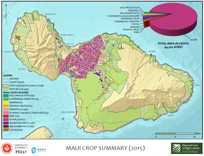
In fact, the majority of Hawaii’s prime-farmland-if-improved designations require only irrigation, an obstacle that is relatively easily overcome through a historic series of ditches and irrigation systems that pulls water from the high water region of the island to the drier more fertile lowlands.
This dataset is also helpful when investigating where to prioritize farmland preservation. Although the total quantity of land in the United States used for agriculture held relatively stable between 2007 and 2012 (the latest year of the U.S. Agricultural Census), the total number of farms during this same period declined and the average size of farms increased. While larger farms may be growing, many smaller farms are struggling each year. According to the American Farmland Trust, over a million acres of farmland are lost in the U.S. due to development. This is especially concerning around high population areas, such as cities and towns, which require large volumes of fresh produce to keep its residents healthy while also exerting considerable development pressure on local farms by escalating land values.
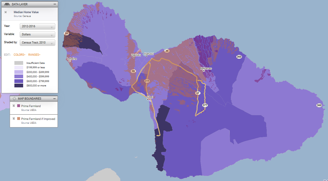
By overlapping median home value with prime farmland designations, we can see where which farmland may experience development pressure from nearby high home prices.
What are the limitations of this data?
While prime farmland and prime-farmland-if-improved designations are interesting to explore and potentially useful when trying to prioritize farmland preservation, they have considerable limitations. To begin with, these designations do not actually indicate the presence of actual farms, just suitable soil. Likewise, although NRI land use categories of water, urban, and built-up land were excluded from these designations, local land use categorizations and zoning restrictions may prevent the use of land for farming. To be successful, farms also require an extensive nearby infrastructure network, including secondary farming systems such as distribution, packaging, supply, and other processes necessary when producing crops.
Moreover, farms can operate in areas outside of these designations. Soil suitability does not take into consideration the ingenuity of farmers to coax plants to grow in less than ideal conditions or the versatility of non-standard crops.
Having grown up on the Big Island of Hawaii in a farming community, I was not surprised to discover that none of the area near my farm was designated as any type of prime farmland, likely due to its geologically recent volcanic activity. However, careful use of pioneer species, terracing, soil augmentation, and growing hardy crops and trees lead to an abundance of fruits and vegetables being grown in the area. Urban farming is also growing in popularity and the frequent use of imported soil and managed irrigation systems circumvents any existing soil conditions.
Despite these limitations, this dataset can provide an insightful snapshot of soil and water conditions best suited to growing standard production crops across the United States.
Due to its granular geography, on PolicyMap, it gets treated as a boundary layer, and can be accessed in the Map Boundaries menu. Because of the large amount of unique processing required to display this data, it’s available only to subscribers and on site licenses.
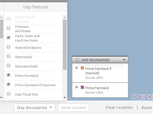
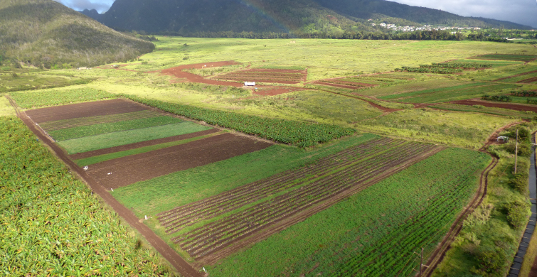
Photo credit: Forest and Kim Starr (cropped)