
The Midwest Floods and Socially Vulnerable Populations
Data
National Flood Hazard Layer
Source
Find on PolicyMap
- Map Boundaries
- Map Features
- High Flood Risk
- Moderate Flood Risk
- Minimal Flood Risk
Data
Social Vulnerability Index
Source
Find on PolicyMap
- Quality of Life
- At-Risk Populations
- Social Vulnerability Index
- Overall Social Vulnerability
- Socioeconomic Status
- Household Composition and Disability
- Minority Status and Language
- Housing and Transportation
Flooding in the Midwest has cost billions of dollars in Missouri, Nebraska, and Iowa and interrupted thousands of lives. Residents that live along the flooded rivers have been forced to evacuate. As spring rains and snowmelt continue to inundate the region, the flooding is predicted to continue and potentially worsen through May.
Putting aside the great cost to infrastructure and agriculture, what people will be worst affected by these floods? Identifying and locating vulnerable populations, like the elderly and those lacking transportation, is important to not only saving lives, but making sure limited resources are used to their best ability.
As we’ve recently discussed, certain populations have less ability to anticipate, manage, and recover from natural disasters like this, due to factors like poverty, household composition, age and disability, language barriers, poor housing, and lack of transportation options. These are referred to as “socially vulnerable populations”, and can be identified using the CDC’s Social Vulnerability Index (SVI). There are different types of social vulnerability, and the CDC has indicators to analyze which ones are most prevalent in an area.
Socially vulnerable populations don’t necessarily live in areas susceptible to disasters like floods, but when they do, they’re often in need of special considerations during evacuation and recovery.
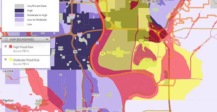
The area around Council Bluffs, Iowa, was significantly affected during the March flooding. Looking at a map of the area, much of the area around the Missouri River, is at high or moderate flood risk. Within that floodplain, there are areas of high overall social vulnerability that would require extra assistance before, during, and after flooding.
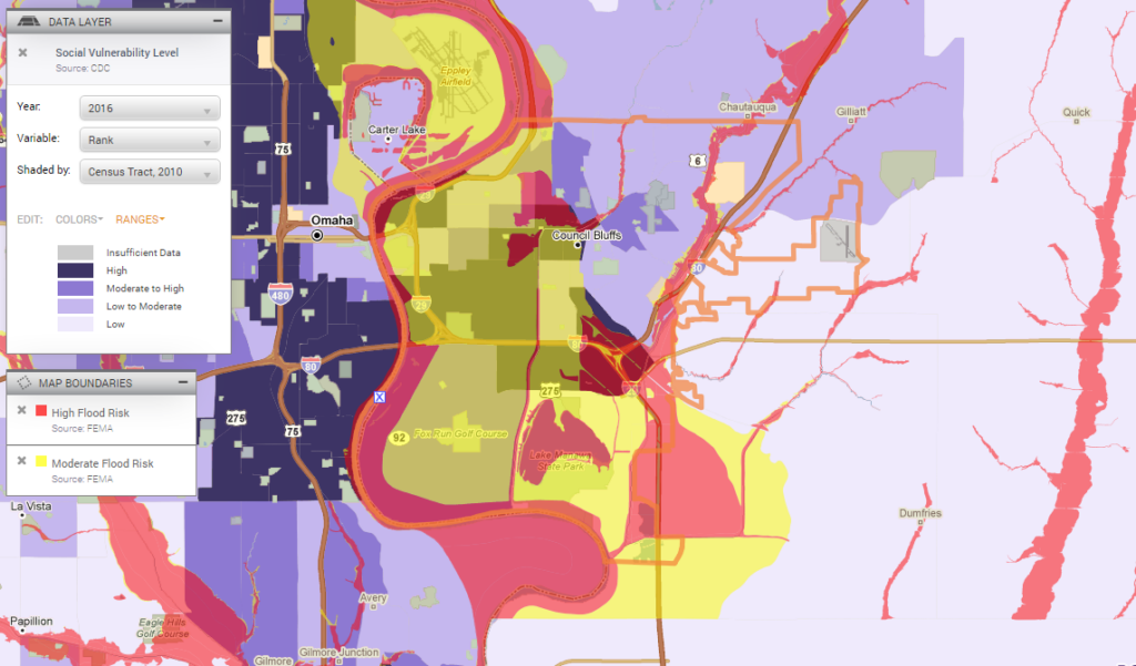
The social vulnerability in Council Bluffs is primarily due to three factors: socioeconomics, household composition and disability, and housing and transportation issues. (Social vulnerability due to minority status and language is also a concern, but less than the other factors.)
Importantly, different SVI factors are present in different parts of the city. At the center of Council Bluffs, officials need to consider the socioeconomic challenges of recovering lost property; to the northwest and southwest, special measures need to be taken to evacuate disabled and elderly populations; and to the west and south, buses may be needed to evacuate crowded households with limited transportation access.
Also important to note, Omaha, across the river, has high social vulnerability levels, but is less prone to flooding. Should flooding extend to those areas, officials there should pay attention to those communities.
Norfolk, Nebraska, another area hit by flooding, also has high and moderate SVI levels. Crucially, the eastern section of the town, where many of the evacuations took place, has particularly high housing and transportation vulnerability, with other factors being lesser concerns. Officials may not need to focus their resources on the poor and disabled, or on economic recovery, but rather on providing housing and transportation during the evacuation.
As another round of flooding hits the Midwest, this data is available in affected cities to help officials target efforts where they’re most needed.