
Using Zip Codes to Understand College Diversity
 Happy Birthday to the Zip Code! Despite the doggedness of the zip code, having been around for 50 years now, we here at PolicyMap have a bittersweet relationship with zip codes. As our blogger Dave Karp has explained (Tips on Zips Series, zip codes are not actual geographic features, so it’s difficult to assign data to them. But our users and the general public have a real use for them, as Professor Danielle Allen explains in her article about affirmative action among universities. In response to this sort of demand, we’ve taken the Decennial Census and the Census’ American Community Survey data and aggregated them to the zip code level.*
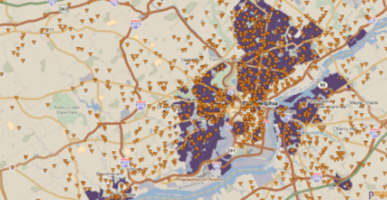
So if, in Professor Allen’s suggestion, universities wanted to analyze their student body by zip code to determine how much geographic diversity is influencing racial, ethnic and socioeconomic diversity on campus, they could easily load a spreadsheet of student addresses into PolicyMap and, with our Analytics tool, quickly understand how much geographic diversity is playing a role in their larger diversity efforts.
For example, say a state university located in Philadelphia wants to understand how they could expand their pool of diverse applicants and evaluate just how much geographic diversity indicates student body diversity. After loading the addresses of students into PolicyMap, administrators could look at areas in which more than half of the population within the zip code is non- white. They could then Download Points to see from which zip codes the students from more diverse neighborhoods actually come. Comparing this student list to the zip codes that have a large non-white population (by clicking Download Places) allows them to see which zip codes they may want to target in years to come.

PolicyMap’s offerings have always allowed our users to conduct such quick studies, but now with our new zip code data, we believe that our users will find more utility with PolicyMap for understanding the places about which they want to learn.
*Please note that the Census provides the 2010 Census Redistricting data and the American Community Survey data at the Zip Code Tabulation Area, or ZCTA. The Census Bureau defines ZCTAs as those areas for which the Census allocated each block that contains addresses to a single ZCTA, usually to the ZCTA that reflects the most frequently occurring ZIP Code for the addresses within that tabulation block. The Census warns, however, that data users should not use ZCTAs to identify the official USPS ZIP Code for mail delivery because the USPS makes periodic changes to ZIP Codes. It is because of this caveat that PolicyMap has chosen to aggregate the data to the Maponics Zip Code geography, which is updated regularly and is officially sourced by the US Postal Service.